

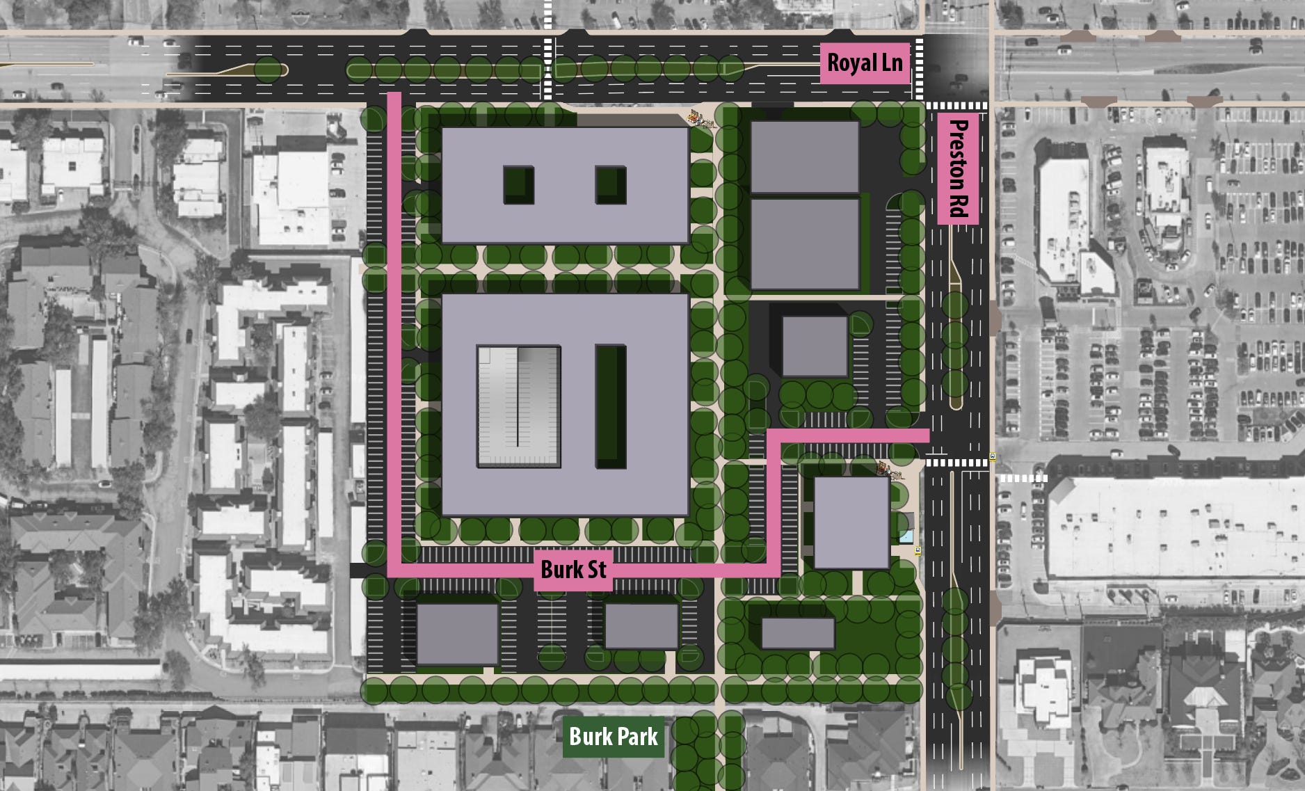
Last week I wrote about a zoning case for a mixed-use development proposed by Burk Interests1 at the southwest corner of Preston Rd and Royal Ln in the Preston Hollow neighborhood of North Dallas. Initially, a hearing was scheduled at City Plan Commission (CPC) on June 25. Two days after my article2, the hearing was rescheduled for August 6.
As has been the case since Burk’s project was first announced by the press last October, the development plan is subject to change between now and its scheduled hearing. That gives us some time to answer a valid question I’ve received many times since I first running this topic by friends and colleagues months ago:
What would a better plan look like?
While I won’t go so far as to produce an actual development plan that Burk’s team can just take and run with—that’s what they pay professional planners for—in this article, we’ll explore ingredients for a better plan from a walkability perspective. Along the way, we’ll try to apply lessons learned from Jane Jacob’s book3, The Death And Life of Great American Cities.
This article is even longer than the last. For the sake of simplicity, and since most of the advise is centered on the development on Burk’s site, I will use the pronoun “you” in reference to Leland Burk himself, as if he were the one reading this article. However, please keep in mind that while he is the target of most of these ideas, many of these ideas require consideration from individuals and entities separate from Burk, including adjacent property owners, traffic engineers, city planners, DART service planners, as well as residents of Preston Hollow.
Also, for readers outside of Preston Hollow, this article will explore many concepts and ideas for good urbanism that apply to any neighborhood. So as you read this, consider it a precursor to a future article about ideas for walkability in your own neighborhood, wherever it may be.
Table of Contents
Accommodate all modes of transport in the correct order
Go big on small bets
In my last article, I explained how my biggest concern with Burk’s project wasn’t the height itself but the amount of debt that height commands: $800 million. This kind of windfall of capital is what Jane Jacobs calls cataclysmic money. At first glance, that much debt may not seem like a big deal because it’s private equity footing the bill, not taxpayer dollars. But the burden of paying back that debt is on the local community whether Burk realizes it or not.
I drew a timeline showing the worst case scenario if the project fails.
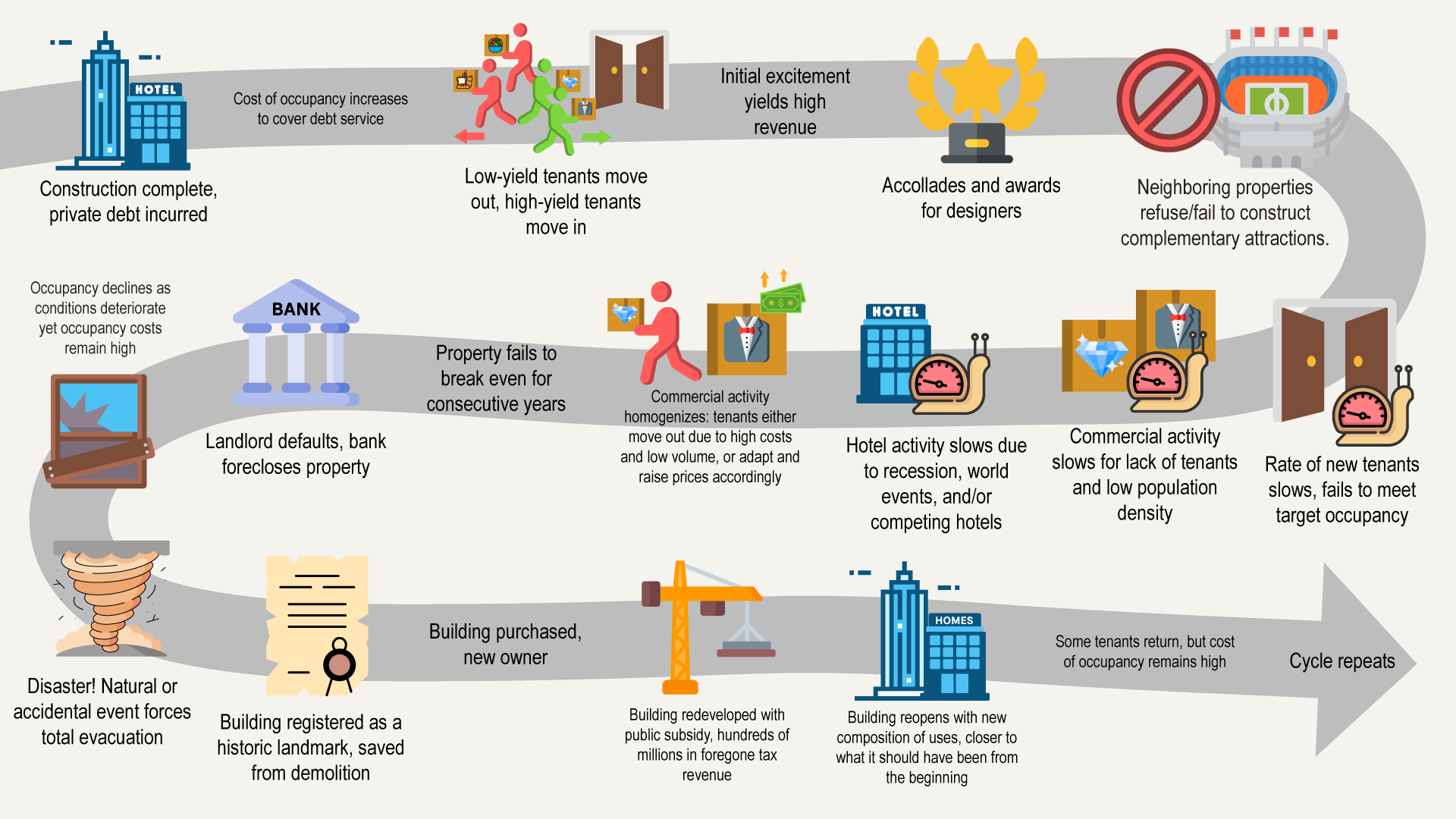
Notice how there are several points of potential failure, both within and without the property owner’s control. Ignoring aesthetics, this is a big part of what it practically means for a project to be “in character” with its surroundings: how many ingredients does the neighborhood have for the project’s long-term success?
Of course, every project of any size carries risk. Does that mean we should never build anything? No. Strong Towns always talks about making “small bets” which have a low cost for starting over or adapting. In the case of Burk’s project, the difference in height between the towers and its surroundings directly correlates with the risk and burden it places on the community.
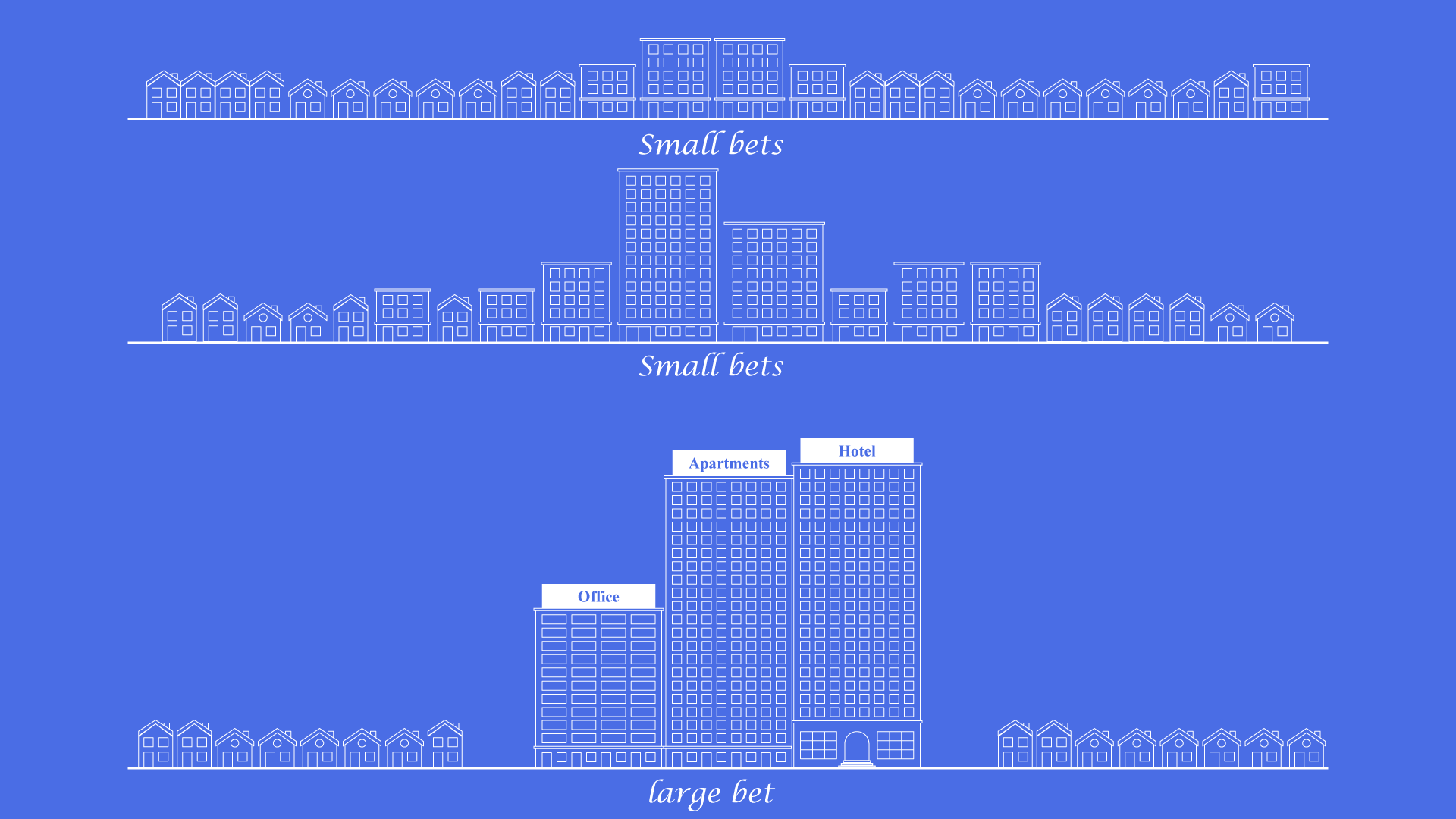
The timeline has small but important details I really don’t want anyone to overlook: if the towers get built, they will be loved. Most likely, the architects will win well-deserved awards for their ingenuity and creativity. People will make positive memories on the property. It will be an icon for the neighborhood, be painted on murals and art throughout the city, and eventually earn historic landmark status.
At this scale, once it’s built, there’s no turning back. The part in the timeline when, after 30-50 years, the structure deteriorates to the point of needing catastrophic repair is not mere possibility—it’s a certainty. Look downtown at all the office-to-residential conversions towers funded by hundreds of millions in TIF dollars. We need more residences, so the conversions are important and necessary. But with city employees being furloughed over a $50 million budget deficit, one can’t help but wish we exercised restraint fifty years ago and built the right thing at the right size at the right time.
Apply the General Theory of Walkability
The General Theory of Walkability is a term coined by author Jeff Speck that explains how, to be favored, walking must have four qualities: it must be useful, safe, comfortable, and interesting. Each quality is essential and none alone are sufficient. The more of each quality a place has, the more walkable it becomes.
Useful means that most aspects of daily life are located close at hand and organized in a way that walking serves them well.
Safe means that the street has been designed to give pedestrians a fighting chance against being hit by automobiles; they must not only be safe but feel safe, which is even tougher to satisfy.
Comfortable means that buildings and landscape shape urban streets into “outdoor living rooms,” in contrast to wide-open spaces, which usually fail to attract pedestrians.
Interesting means that sidewalks are lined by unique buildings with friendly faces and that signs of humanity abound.
Maximize the usefulness of every step
Currently, the Walk Score—a metric based primarily on the quantity and variety of uses—for the Preston/Royal intersection is 80. That’s actually not bad. Of course, there’s room to improve, figuratively and literally. Personally, I’m fond of the Lowest Greenville neighborhood with a score of 92.


While Walk Score is not the sole measure of walkability, it’s a good place to start, and you can’t go wrong by trying to get your Walk Score as high as possible.
Don’t be fooled by superficial diversity
One of my biggest pet peeves is when a project sells itself as a “walkable mixed-use development” yet the pedestrian accommodations are limited to on-site, and the mixture of uses aren’t particularly numerous or diverse.
From a developer’s perspective, the project sounds diverse because they’re not counting uses, but rather property types. In this regard, saying that a project combines “apartments, condo, hotel, office, food and retail” sounds a lot more diverse on paper than simply “apartments, food, and retail.”
However, the way developers measure diversity doesn’t always track with what diversity means in practice for neighbors, especially those arriving on foot. A neighbor may count “convenience, crafts, books, bikes, plants, and toys” as six different uses, while a developer would count all that under one property type: retail.
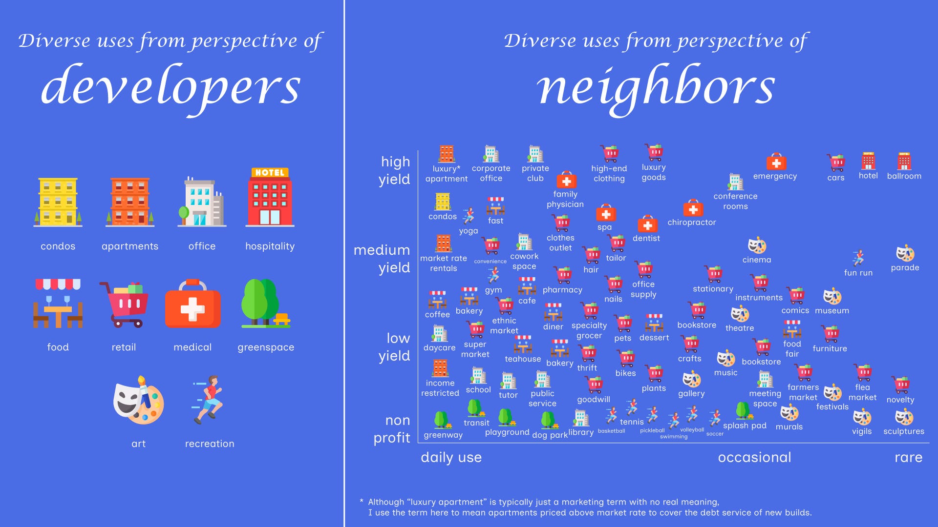
It may seem pedantic, but it’s important to understand these differences because when discussing the project’s propensity for diverse uses, the developer and the neighbors may end up talking past each other. The developer might not understand how, despite adding a new property type (hotel), the development plan may actually reduce diversity of uses because the variety of tenants who can afford to lease space in a $10 million building is far greater than those who can afford to lease space in an $800 million complex.
A goal of mixed-use development should not be to achieve the impossible task of fitting every use under the sun on a single site, but rather to maximize the variety of walkable uses available to neighbors, thereby minimizing the need to travel outside the neighborhood by car.
Developers should be mindful of how building high intensity of certain uses (luxury hotel and corporate office) can reduce overall diversity. Conversely, developers should also consider how providing a high volume of residences increases overall diversity by providing the population necessary to support medium- and low-yield ventures.
Build a neighborhood hub, not (another) regional center
Preston/Royal is a terrible location for a regional center for several reasons, one being how there are several competitors nearby, including Preston Center and NorthPark Center. Yet when we look at its traditional boundary, the only commercial zone in Preston Hollow is the Preston/Royal intersection.
This means while neighbors are already spoiled for choice when it comes to intermittent and rare uses worth driving for, Preston/Royal is the only option within walking distance for daily and regular uses.
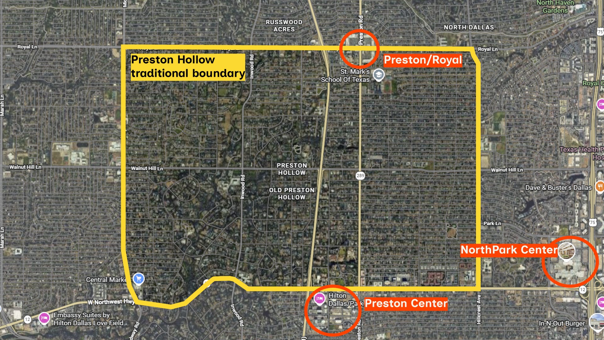
When deciding what variety of uses to accommodate in the site plan, the developer should be mindful of how he’s in a unique position to provide certain uses the neighborhood desperately needs—residential density, neighborhood services and amenities—and resist the temptation to provide that which the area is already saturated—hotels, office, high-end dining and retail.
Research gaps in desired uses among neighbors; incorporate solutions into the project design
Take time to research what commercial services and amenities are available in comparable neighborhoods yet missing from Preston/Royal. For example, there are already multiple options for coffee, grocery, and restaurants. But what about a bike shop? Or a plant shop? Or an art gallery? Or a black-box theater?4 There are likely several uses neighbors want that don’t fit the available leasable space.
Don’t just research the commercial corners; talk to nearby schools, churches, institutions, and the residents themselves. Ask existing business tenants what complementary businesses they’d like to have on their block.
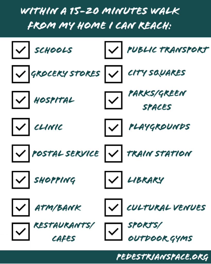
Maximize use of liminal space for transportation, recreation, and special events
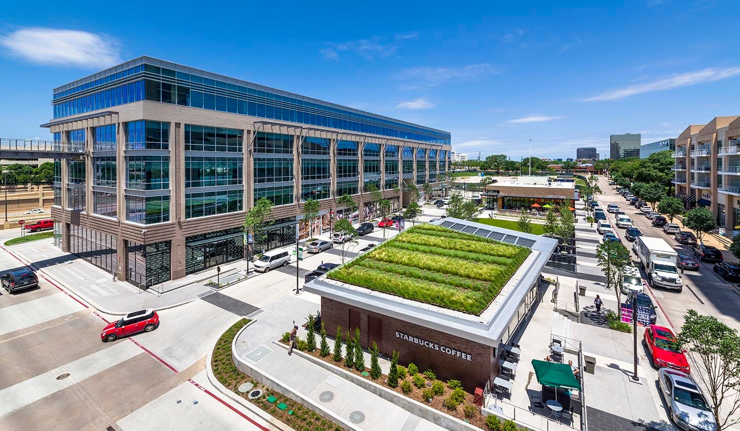
One of my pet peeves is when designers attempt to create “third places” located somewhere you need to go out of your way to find—i.e. the act of going there is a chore unto itself. An example of this can be found at The Shops at Park Lane. Notice how the plaza is hidden away from all other sources of foot traffic, such as the DART station and the playground.
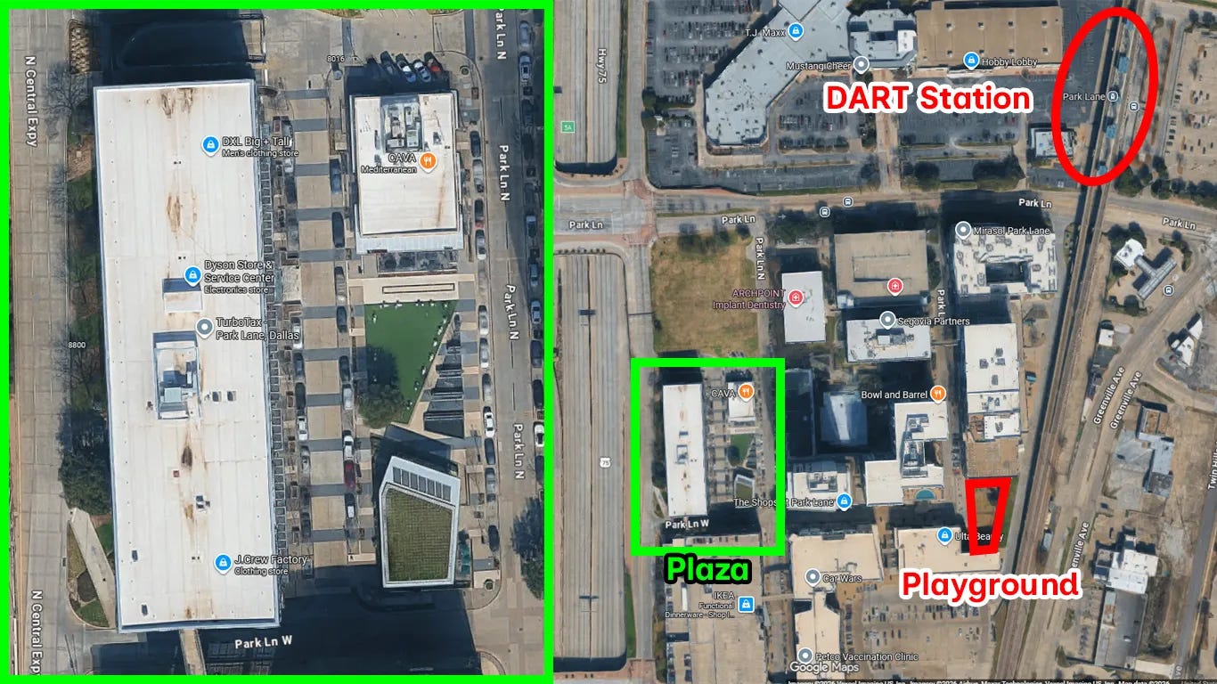
The result is a “public green space” that looks pretty in marketing material, and, in all fairness, is a nice amenity for the 550 households that live in the mixed-use development. But the plaza does not provide provide meaningful value to the larger neighborhood because it does nothing to enhance the walk of any pedestrians destined for anywhere that isn’t the plaza itself.
Most people I speak to who live within two miles of the Shops at Park Lane have no idea the plaza even exists, nor do those using the nearby DART station. For anybody going out of their way to reach the plaza on foot, the walking experience is notoriously awful for lack of a consistant foot path between the plaza and the outside world.
When we look at the plans and renders for Burk’s project, we see a similarly vain attempt at creating “green space for the community” that’s practically walled off from said community. Other than the on-site tenants, who do we expect to go out of their way to patronize this hidden green? The marketing renders may look pretty, but for the few people who do go out of their way to visit on foot, this looks like the kind of place where (speaking from experience) after ten minutes of lounging on the grass will be interrogated by private security.
Don’t get me wrong, there’s nothing inherently wrong with private greens. Apartment-dwellers have just as much right to having their own lawn as single-family homeowners do. But we need to be honest about the difference between private lawns and the public realm, the latter of which is what is we need to enhance walkability.
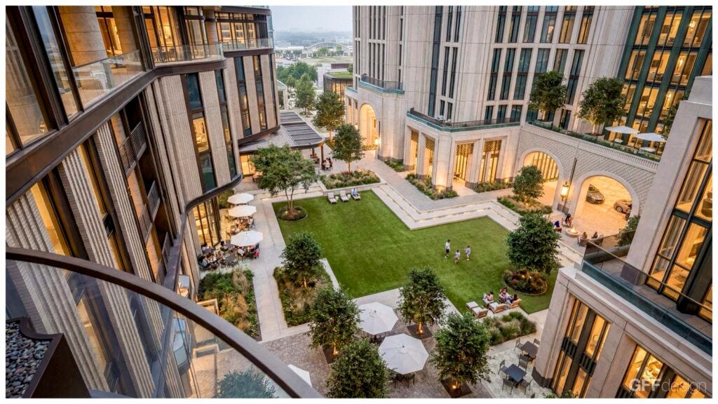
Instead of a walled garden, try building a linear park instead. This way, pedestrians and cyclists benefit from the safety and comfort of your green space, whether their trip starts or ends on-site, or if they’re just passing through. For extra utility, design the linear park in a loop so it can be enjoyed by neighbors walking their dog, window shopping, or having a leisurely stroll.


To really make this a center for the community, design the linear park so that it can accommodate vendor tents on either side of the walkway. Imagine flea markets, block parties, and holiday celebrations in this space.
By fusing your green space and liminal space together, you transform this project from a private endeaver yielding profit for a handful of individuals, to a neighborhood center generating wealth for the entire community.


Accommodate all modes of transport in the correct order
Drivers should still be accommodated, but not ahead of pedestrians, cyclists, public transit, and rideshare passengers, in that order.
Note that many of the ideas in this section go beyond the bounds of Burk’s property. Many of these suggestions involve reconfiguring the local street grid. We’ll go into more detail on these off-site changes in the penultimate section titled Fix the stroads! For now, the suggestions in this section will gloss over the issue of ownership.
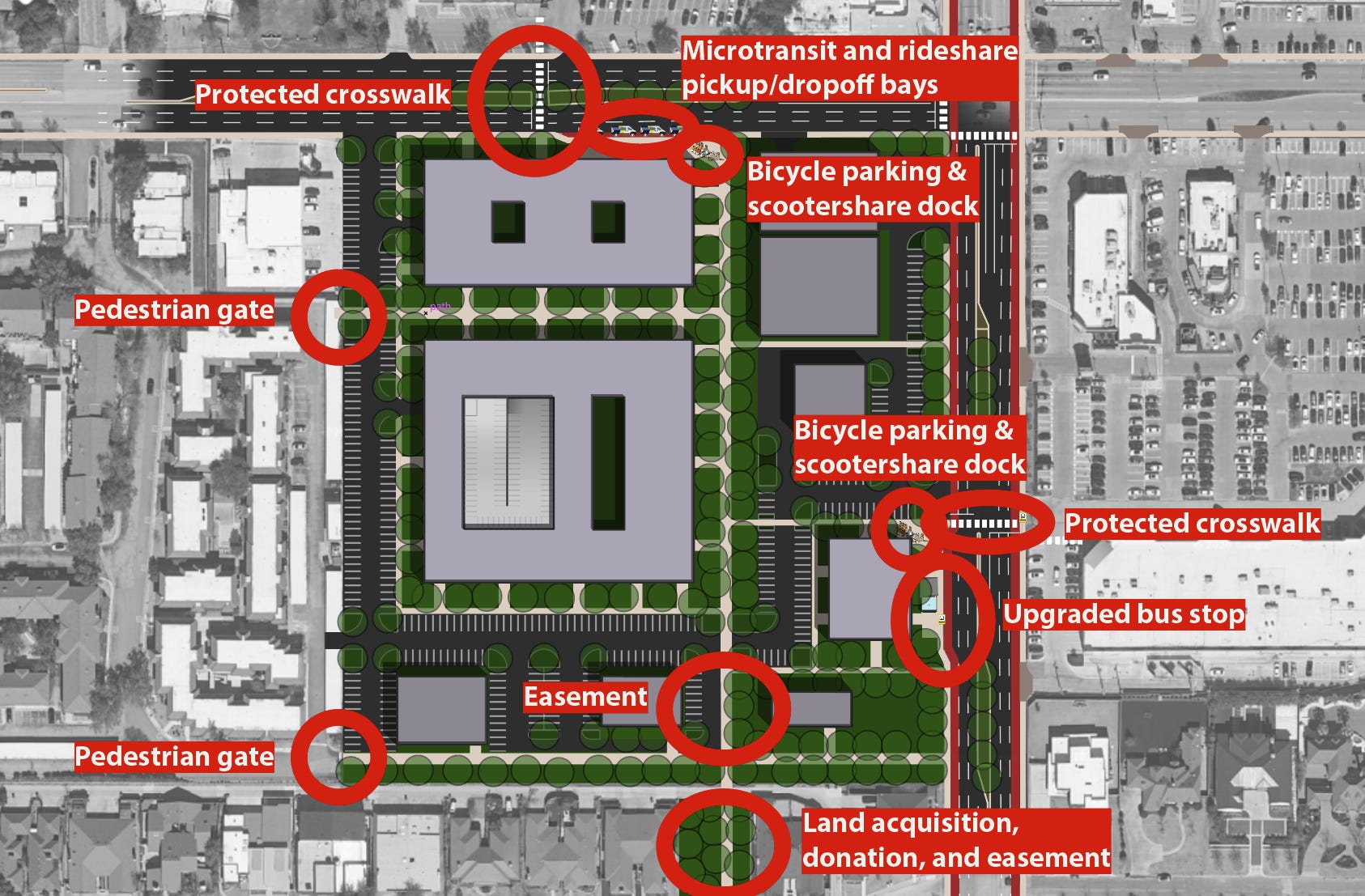
ADA Accommodations
When writing this list, I was tempted to designate “people with disabilities” as a separate category and put them at the top of the list. However, it occurred to me that, while public discourse often describes them this way, it is wrong to suggest that having a handicap is mutually exclusive from being a pedestrian, cyclist, transit rider, or driver. So as we talk through each mode in order, remember that people of different abilities should always be accounted for in every category.
Pedestrians
This project is a rare opportunity to break the habit in Dallas of treating pedestrians as an after-thought. Instead of designing around cars first and forcing everyone else to take long detours and play frogger on driveways and parkings lots, provide first-class comfort to patrons who arrive without a vehicle. This includes people walking from home, as well as those using wheelchairs, walkers, and crutches. Arriving without a vehicle should feel like the most correct way to arrive.
Pedestrian alley lined with storefronts
It’s self-evident how this design technique makes walking more useful, comfortable, and interesting. It also improves safety by increasing, as Jane Jacobs calls it, the number of eyes on the street.
Second, there must be eyes upon the street, eyes belonging to those we might call the natural proprietors of the street. The buildings on a street equipped to handle strangers and to insure the safety of both residents and strangers, must be oriented to the street. They cannot turn their backs or blank sides on it and leave it blind.
And third, the sidewalk must have users on it fairly continuously, both to add to the number of effective eyes on the street and to induce the people in buildings along the street to watch the sidewalks in sufficient numbers. Nobody enjoys sitting on a stoop or looking out a window at an empty street. Almost nobody does such a thing. Large numbers of people entertain themselves, off and on, by watching street activity.


An obvious benefit of packing as many storefronts onto a shared walkway as possible is it maximizes the use of every step. Another benefit is it increases opportunity for what Jane Jacobs calls secondary diversity.
Primary uses are our reasons for leaving the house. These are common things like coffeeshops, cafes, grocery stores, libraries, offices, and other uses we can plan, build, and control for. Secondary diversity are activities that only work well when you have sidewalks full of life and activity. Familiar examples include youth selling fundraiser cookies, sidewalk performers, flea markets, and popup vendors.
Any primary use whatever, by itself is relatively ineffectual as a creator of city diversity. If it is combined with another primary use that brings people in and out and puts them on the street at the same time, nothing has been accomplished. In practical terms, we cannot even call these differing primary uses. However, when a primary use is combined, effectively, with another that puts people on the street at different times, then the effect can be economically stimulating: a fertile environment for secondary diversity.
Secondary diversity is a name for the enterprises that grow in response to the presence of primary uses, to serve the people the primary uses draw. If this secondary diversity serves single primary uses, no matter what the type of use, it is innately inefficient. Serving mixed primary uses, it can be innately efficient and—if the other three conditions for generating diversity are favorable also—it can be exuberant.
If this spread of street use spreads a variety of consumer needs or tastes through time of day, all sorts of uniquely urban and specialized services and shops can make out, and this is a process that builds upon itself. The more intricately mixed, and therefore efficient, the pools of users are, the more services and shops there can be that need to sift their clienteles from all sorts of population, and in turn the more people are drawn.
Pedestrian gates
Reach out to the condo neighborhood association to the west of the site and negotiate installing two walk gates—north and south—providing direct access for 200 households. It’s common for walk gates between private properties to have an access control system (keyfob, access code, callbox, etc) to prevent tresspassing.
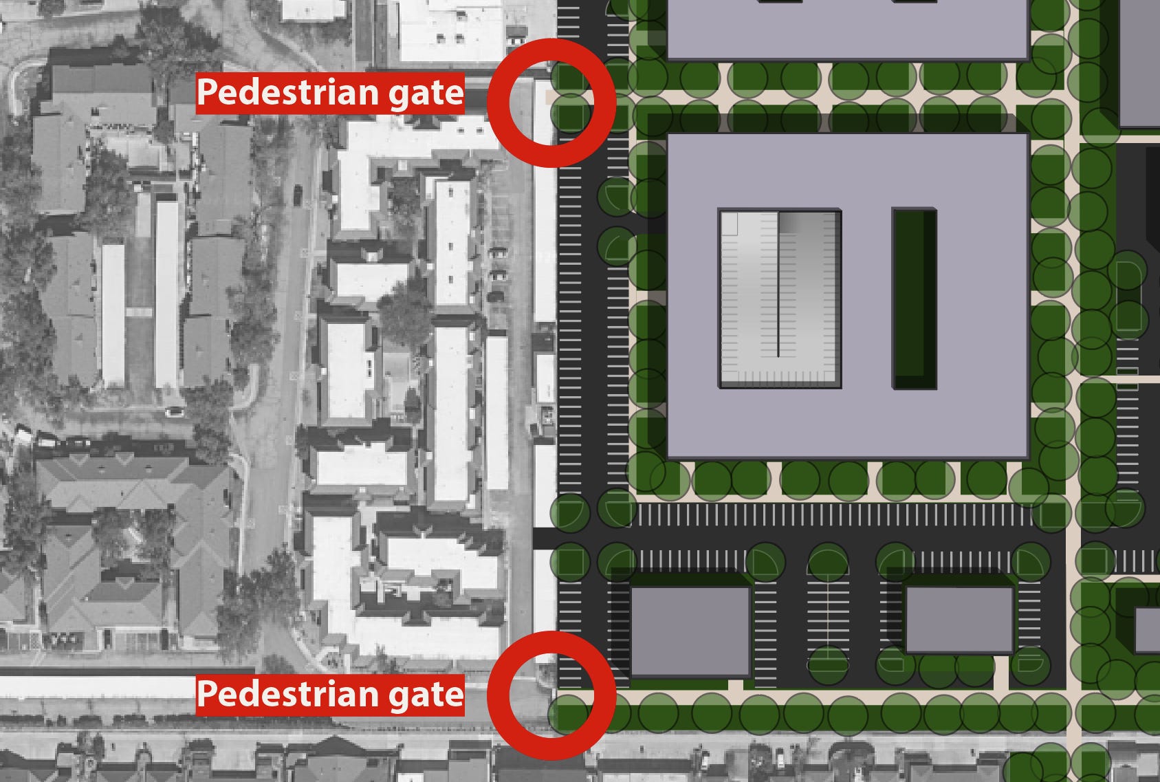
Those new to the topic of walkability may wonder why add two walkways when one is enough to serve the site. The answer has to do with “the need for small blocks,” as Jane Jacobs put it:
CONDITION 2: Most blocks must be short; that is, streets and opportunities to turn corners must be frequent.
Jacobs dedicated an entire chapter to this matter. In summary, shorter blocks mean businesses are more discoverable to people on foot. And when the urban design is such that the number of sidewalk users numbers in the hundreds (or even thousands) per day, the result is free organic marketing that money can’t buy.
Pocket Parks on Orchid Ln
Currently, any family wishing to walk or bike with their kids from the townhouses south of Burk’s site must travel all the way to Preston Rd, which has seven lanes of traffic and no sidewalk. If they walk on the grass, there are trees, a utility box, utility poles, and two driveways without curb cuts in the way.


Frankly, there’s no solution that doesn’t require cooperation from several independent entities. Might as well go with an obvious solution that’s safer and less technically challenging (i.e. doesn’t require moving a utility box).
First, I suggest buying the two empty lots on Orchid Ln, converting them into pocket parks, and donating them to the city. In addition to providing a safe way in and out of the neighborhood, it also provides shared green space to a subdivision that currently has none.
Maybe name it Leland Burk Park. Has a nice ring to it, doesn’t it? For inspiration, see the pocket park trail in the Cochran Heights neighborhood of Old East Dallas.


From there, cut a trail opening in the wooden fence behind the alleyway. Reach out to the owners of the adjoining properties about similarly donating a slice of their parking lots to bridge the gap between the parklets and the site trail.
Voila! You’ve not only created a safe path to your own site, but also to all the other establishments on the other corners of Preston & Royal.
Pedestrian Safety Islands and/or HAWK Crossings
Crossing seven lanes of traffic on Preston and Royal require more than white paint to make safe. Consider using one or both options for midblock crossings on each road.
A pedestrian safety island, also known as a pedestrian refuge island, is a concrete barrier in the middle of a road allowing pedestrians to cross one direction of traffic at a time. They usually come with a yellow flashing signal light that pedestrians activate by pushing a button before crossing. The flashing signal warns drivers to slow down and yield to pedestrians in the crosswalk. Nice examples of these can be found on Jefferson Blvd, south of Bishop Arts, and Synergy Park Blvd between the UTD Campus and the DART UTD Station in Richardson.


A High Intensity Activated Crosswalk (HAWK) is for pedestrian crossing of major streets. Similar to safety islands, HAWKs have a push button that immediately activates a signal light. But unlike safety islands—which only flash yellow to warn drivers to yield—HAWK crossings briefly shine yellow, then flash red compelling drivers to come to a full stop. A nice example can be found on Singleton Blvd by the Trinity Groves neighborhood in West Dallas.


Notice that HAWKs usually don’t have a physical barrier in the roadbed like safety islands do. If it were up to me, I’d try to fit both a HAWK signal and a safety island to get as much protection as possible for families crossing Preston or Royal. But, I imagine some haggling with DDOT is inevitable.
If you can convince DDOT to go with both (by offering to pay for both) then get both. Otherwise, do what you can to get at least one of those protections. Risking people’s lives is not worth saving one minute of drive time.
Trees and shade at every step
Currently, there’s no way to walk to the site without suffering the full heat of the sun from above and from below as it radiates from asphalt driveways and parking lots. Fix this by identifying every walk vector to your site and plant trees everywhere, including offsite where possible.
Try to ensure pedestrians are shaded from both sides as much as possible, either with trees, or a building, or both. Add an outdoor water feature to shave a few more degrees. Apply all these techniques, and a 90° day can feel like 75°, or a 100° can feel like 85°—you will have created a space that’s habitable year round.


Cyclists and Micromobility
Bicycle accommodations serve more than just spandex-clad enthusiasts. Designing for cycling also means serving youth, parents with strollers, wheelchair and mobility scooter users, and any of the third of Americans for whom driving is not an option.
In addition to providing convenience to neighbors, accommodating and promoting cycling is a boon to small businesses: according to a study in Portland, OR, bike riders shopped more frequently and spent 24% more per month than people who shopped by car: $75.66 on average for bike shoppers, compared to $61.03 for car drivers.
There are many reasons for this. The ease of parking and reparking a bicycle makes it easy for people on bikes to hop in and out of stores. Fast-moving streets make it harder for potential customers to discover local stores; streets with protected bikeways and plenty of bike parking provide a more enjoyable experience for all shoppers and encourage people to linger.
In fact, according to data in the Protected Bike Lanes Mean Business study, car parking generates $0.19 in retail revenue per hour per square foot while bike parking generates $0.69 per hour. Taking away a few car spots can provide space to park two dozen bicycles. Paired with a safe, connected bikeway network, encouraging bike shoppers is a great way to generate retail sales.
The Preston/Royal intersection holds more cycling potential than meets the eye. For starters, over 54 thousand people live within a 15-minute bike ride. The 9.3 mile Northaven Trail is less than a half-mile away. At the edge of the 15-minute bikeshed are two DART light rail stations: Walnut Hill and Forest Lane. Cycling north reaches the Valley View Mall site, future home of the Dallas Mavericks; south reaches past Preston Center on Northwest Highway. Perhaps most importantly, every single school in Preston Hollow is less than 15 minutes from Preston/Royal.


It’s far from perfect, but frankly North Dallas has many of the ingredients for bike-oriented car-free living. With a few simple design changes, Preston/Royal could genuinely become a place where people prefer cycling over driving.
Every improvement for pedestrians listed above also supports cyclists. Beyond that, here are more ideas specifically for accommodating and promoting cycling to, from, and through the site.
Put bicycle parking everywhere
In my humble opinion, there’s no such thing as too much bicycle parking. By liberally sprinkling bicycle parking all over the site, you’re not only making life that much more convenient for patrons arriving by bike, you’re also signaling to all who arrive that cycling is a preferred mode of travel—especially to those arriving by car.
One of my biggest gripes is when bicycle parking is practically hidden. Not only does this force cyclists to waste time circling the site in search of parking, it also means there’s no way to keep an eye on it while patronizing establishments. I recommend placing at least one bike stand near each doorway, and a large bike corral within eyeshot of every doorway (all storefronts on the same alleyway can share the same corral). The idea is to make finding parking as fool-proof as possible for anyone pulling up to an entrance on a bike.


Bike parking at transit stops
We’ll explore ideas for where to locate transit stops in the upcoming section on Public Transit. Wherever they’re placed, install a generous amount of bike parking nearby. This supports transit riders who (especially after you build trails into the site plan) use their bicycle to shorten their trip from home to the transit stop. While every DART bus comes standard equipped with a bike rack, many people only need their bike for the first leg between home and the bus; they don’t always need to bring it to their final destination. By having bike parking at the transit stop, multi-modal travelers can lock their bike at the stop, go about their day, then return to retrieve their bike and go home at the end of the day.
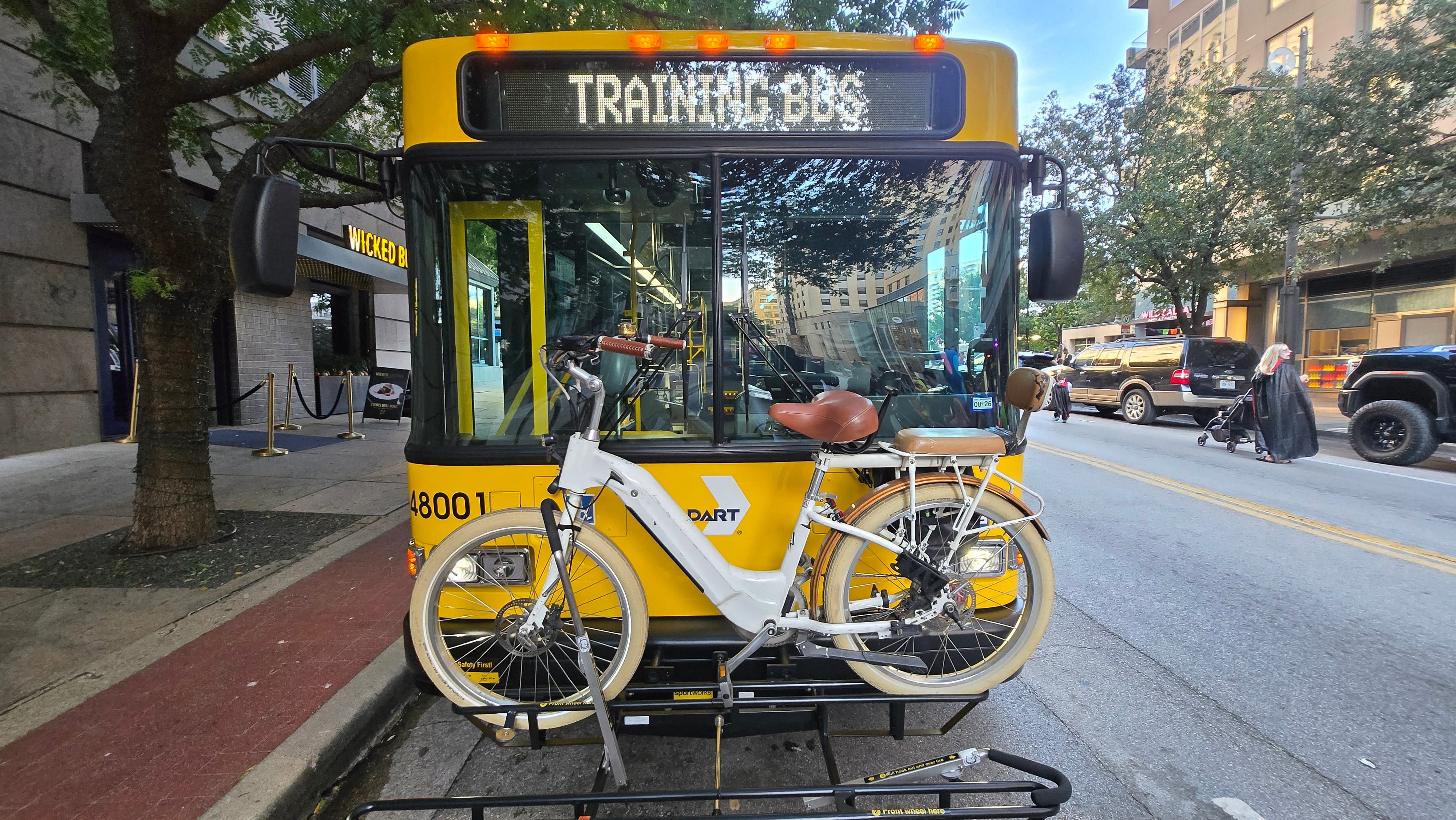
Design for Cargo Bike Parents
Across America, we’re seeing a growing number of parents transporting their kids around on cargo bikes. This trend is supplemented by a growing variety of e-bikes specifically designed for transporting multiple children plus groceries at the same time. Maddy Novich, a mother of three in NYC, made a name for herself as Cargo Bike Momma on social media showing off how she lives car-free using cargo bikes like a family minivan.
We see this trend growing in Dallas too. Anyone who lives in Bishop Arts, Lower Greenville, Deep Ellum, Uptown, and The Cedars has at some point seen them zipping around the neighborhood with one, two, sometimes three kids in tow.


The redevelopment of Preston/Royal provides a distinct opportunity to accommodate “cycling minivans” in ways that current structures do not.
Design the front of retail space to have loading zones for cargo bikes. This detail goes hand-in-hand with my earlier suggestion to include bike parking near every entrance. Make sure the dimensions of your loading zones are wide enough for the extra length of modern cargo bikes.
In your multifamily buildings, include secure bicycle lockers as an amenity, again making sure the locker dimensions can accommodate the length of cargo bikes as well as allow easy access for its passengers and cargo.
Public Transit
While Preston Hollow public transit isn’t plentiful at this time, a lot can be done to support existing service and lay the foundation for upgraded service in the future.
Position upgraded transit stops at crosswalks
On Preston Rd, reposition bus stops to where the new crosswalks will be. This makes it easy for patrons arriving by bus to conveniently cross no matter which direction they’re coming from. On the side of Preston Rd touching Burk’s site, cut a bus pullout lane so that bus operators aren’t pressured by drivers behind. The pullout lane can also be used by GoLink and paratransit vans picking up and dropping off passengers.
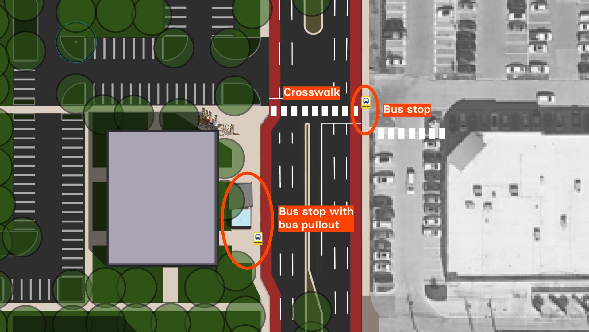
On Royal Ln, there currently is no bus service. However, it doesn’t hurt to plan for the future and incorporate a pullout lane for transit vehicles here. In the meantime, the transit stop can be used by GoLink and paratransit vehicles.
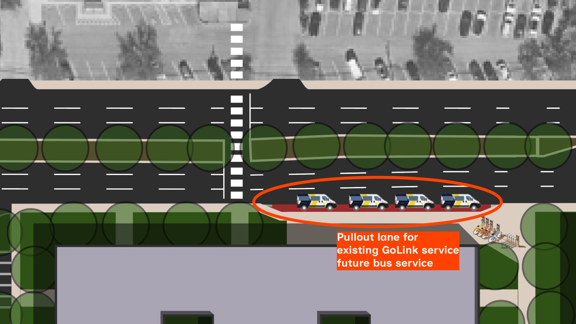
Extend the GoLink zone
If you don’t already know what GoLink is, watch this short video to get caught up to speed. Preston Hollow is served by three GoLink zones: Preston Hollow, North Dallas, and North Central Dallas. This means you can book a cheaper-than-Uber on-demand trip from anywhere to anywhere within these three zones.
However, if you go to the DART website to plan a trip to the site today, it won’t give you GoLink as an option. This is because the way DART currently has the zones drawn excludes the west half of Preston Rd.


This is a simple fix, as DART service planners regularly field requests for zone changes and make adjustments accordingly (notice how Preston/Forest already has the zone extended to cover all four of its corners) After building new transit stops as per my prior suggestion, I suggest DART extend the GoLink zones by adding the new transit stops as “rally points”—designated pickup/dropoff locations for GoLink vehicles.
Parking
After reading this far, I hope by now you’ve learned there is more to walkability than just shoving your parking underground.
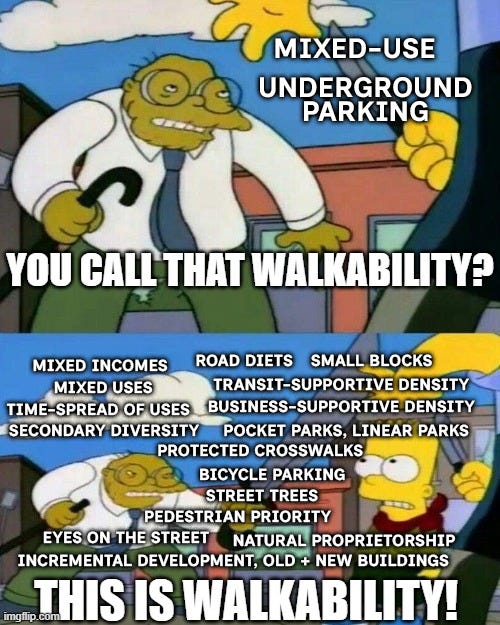
I’m not so naive as to suggest you don’t need parking in 2026, nor that by applying all these suggestions all your customers will miraculously stop using their cars. I will say that there are more innovative ways to utilize parking while improving walkability that go beyond just hiding it underground.
Encourage shared parking instead of exclusive parking
Whether viewed from above via satellite or on the ground in real life, the first thing anyone notices about Preston/Royal is the obscene amount of asphalt.
Just looking at a photo makes my skin feel like it’s heating up…
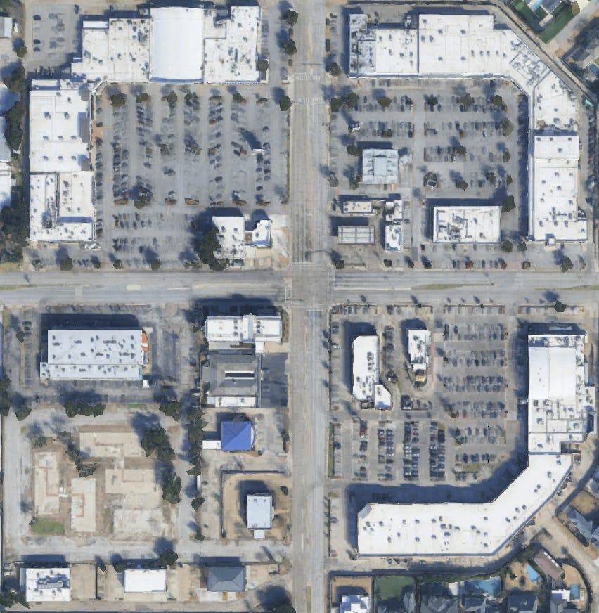
There’s a lot of problems to unpack here, but perhaps the biggest is that none of the corners are designed to share parking with the others. When we zoom in on the southwest corner alone, we can see it’s even worse with adjacent properties not only supplying their own parking but also having redundant driveways.
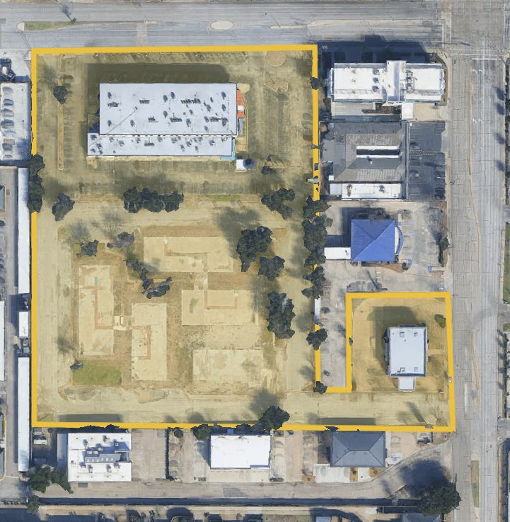
We’ll explore solutions to all this in greater detail in the penultimate section titled Fix the Stroads! For now, the idea I want you to consider is planning a Shared Parking Agreement between all adjacent properties on the southwest corner. Taking this idea a step further, you may even consider extending the agreement to all four corners of Preston/Royal, not only so they can share in your parking, but also so you can share in theirs as well.
You can see an example of shared parking at work in the Lowest Greenville neighborhood. The system is far from perfect—every parking lot has its own shared agreement with select businesses, resulting in a patchwork of agreements that confuse drivers over where they can and can’t park. While there’s plenty of room for improvement—making parking utilization more efficient, thereby allowing more surface lots to be turned into housing—it’s fair to say the neighborhood is a lot more dense and walkable now than it might have been if buildings didn’t share parking at all.


Don’t let garage parkers miss out on sidewalk encounters
It’s a given that, at least in the beginning, most patrons to your site will arrive by car. Even so, you still want to increase sidewalk life as much as possible. Thus, if you build a parking structure (be it above or below ground), design it so that visitors who park in the structure must return to and use the sidewalk just like any other patron arriving on foot. Tenants may still have direct private access between the garage and their unit, but visitors should contribute to the vibrancy of your street life.
The first reason is ego: we want walking to be the priority mode of travel, and we don’t want to reward driving over walking by giving drivers an exclusive and more convenient point of entry that pedestrians—who have no use for the garage—won’t have access it.
The second reason is safety: by providing an alternate ingress point for drivers, not only are you reducing the number of eyes on the street providing organic safety for everyone, you’d also be forcing your limited security personnel to split their attention between driver and pedestrian ingress. Inevitably, since most visitors are still expected to arrive by car, officers will choose to prioritize ingress of drivers, thereby reducing safety for those who chose to arrive on foot.
The third reason is business: the value of walking is about more than just geting you to your destination, but also what happens to you on your jouney. Being on the sidewalk exposes patrons to neighboring and complementary enterprises that they wouldn’t have encountered had they only walked from their driver door to the front door. This is the type of organic exposure money can’t buy, and its integral to profitability for you as the landlord as well as your tenants.
Plan phases to keep existing tenants
There are currently twenty-or-so commercial tenants in the existing structure on your site. Design your plan so that the first new structure built on undeveloped land has enough groundfloor commercial space for all the tenants occupying the existing structure. This prevents a net loss of commercial services and amenities for the neighborhood during and after construction.
Build more residential density
In the first half of this article, we talked a lot about how an excess of certain land uses (namely hotels and office) can hurt overall diversity. However, when it comes to residential density, it’s hard to say how much is too much. If you’re going to risk building excess of anything, err on the side of too much housing.
Density supports businesses
To sustain profitability, a typical small coffeeshop needs between 100 to 150 customers per day. Based on the percentage of Americans who go out for coffee daily, and assuming a conservative 10% market capture rate, a typical shop needs a market population between 9,000 and 14,000 people.
How many people live within a 15-minute walk of Preston/Royal? Barely 2,600.
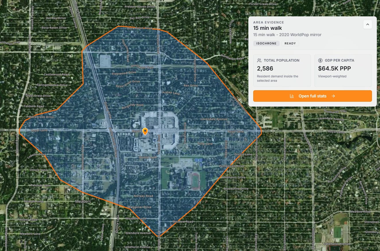
Yet the commercial district has multiple coffeeshops. How is this possible? Of course, we know it’s because the vast majority of customers drive in. This may work for now, but the harsh truth is this environment is fragile for business. The number of customers through the door is deeply affected by the price of fuel and the flow of traffic, which only gets worse each year. These car-dependent businesses are more susceptible to outside competition; if all your customers drive in from outside the neighborhood, what happens when a competitor opens closer to home than you?
Being car-dependent also means being parking-dependent, which locks the entire business community in a vicious cycle of dependency: they can’t build density because they need parking, and they need parking because they don’t have density.
Your site, being largely undeveloped and not currently used for parking, provides a unique opportunity to provide enough density not only to sustain itself, but also to break the cycle of dependency for all four corners of Preston/Royal.
Let’s run some hypothetical numbers…
We start with our current walkshed population of 2,600 people, of which we have greater access to thanks to all the walkability upgrades suggested in this article. Suppose you add a total of 500 apartments/condos. With Preston Hollow’s average household size of 2.19, that’s a population boost of 1,095, giving us a walkshed total of 3,695 people, or 41% of the population threshold to support a coffeeshop.
Let’s use lazy math and assume that means the next corner can convert 41% of their surface parking into 205 housing units. That’s an additional 449 people, bringing our population total to 4,144. Keep this pattern going for the remaining two corners, and our walkshed lands at 5,213 people, or 58% of threshold and 200% of the population we started with. If the other three corners copy all the walkability improvements for Burk’s site from this article, they would tap into the population of 54,000 people currently in the 15-minute bikeshed of Preston/Royal.
All this and more is possible if Burk would just build more housing instead of more hotels and office.
Density supports transit
Preston Rd is currently only served by one bus: Route 237 serving Addison (DART Silver Line Station), Pepper Square, Valley View Mall (future Mavs arena), Preston/Forest, Preston/Royal, Preston Center, Highland Park Village5, Oak Lawn, Uptown, and Downtown Dallas.
In terms of destinations served, this is honestly a great route. It’s one dealbreaker is it has super low frequency: 30 minutes at peak, 40 minutes off-peak, 60 minutes at night. With all the high-profile destinations it serves, why did DART give this route such low frequency? The answer is obvious: over half of the route—the entire stretch of Preston Rd in North Dallas south of LBJ Freeway—is super low density.
Now imagine if, as described in the prior section, the Preston/Royal population doubled to 5,213 people. Then imagine Preston/Forest doing the same, bringing another 5,200 people to the Preston Rd corridor. Having that much density along Preston Rd would certainly warrant higher frequency on Route 237, something closer to DART’s core frequency of 15 minutes peak, 20 minutes off-peak.
Fix the stroads!
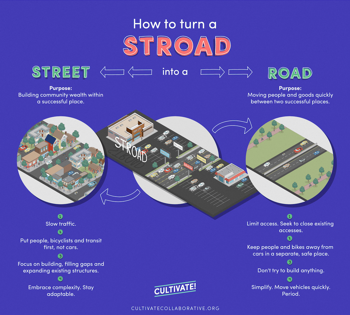
If we want to build towns that are safe and financially productive, we need to identify and eliminate stroads. A stroad is a street/road hybrid. Both Preston Rd and Royal Ln are classic stroads: they prioritize both speed (with seven to eight lanes each) and access (with several driveways and unsignalized left turns) at the same time, and do a terrible job at both.
There’s a lot of material online on the topic of how to fix stroads. We’ll explore ideas for de-stroad-ing Preston and Royal here. Fixing stroads is very expensive because it requires a thoughtful yet complete overhaul of a local grid. However, the scale of Burk’s project presents an opportunity to leverage private capital to implement fixes that would otherwise cost taxpayers a fortune.
Convert Preston and Royal from stroads to roads
Let’s start by converting our main arteries—Preston Rd and Royal Ln—into proper roads that prioritize safe movement over convenient access.
Consolidate multiple driveways into one or two streets.
Minimize unsignalized left turns.
Use larger medians for trees and pedestrian safety islands.
Here’s what that could look like for Royal Ln:
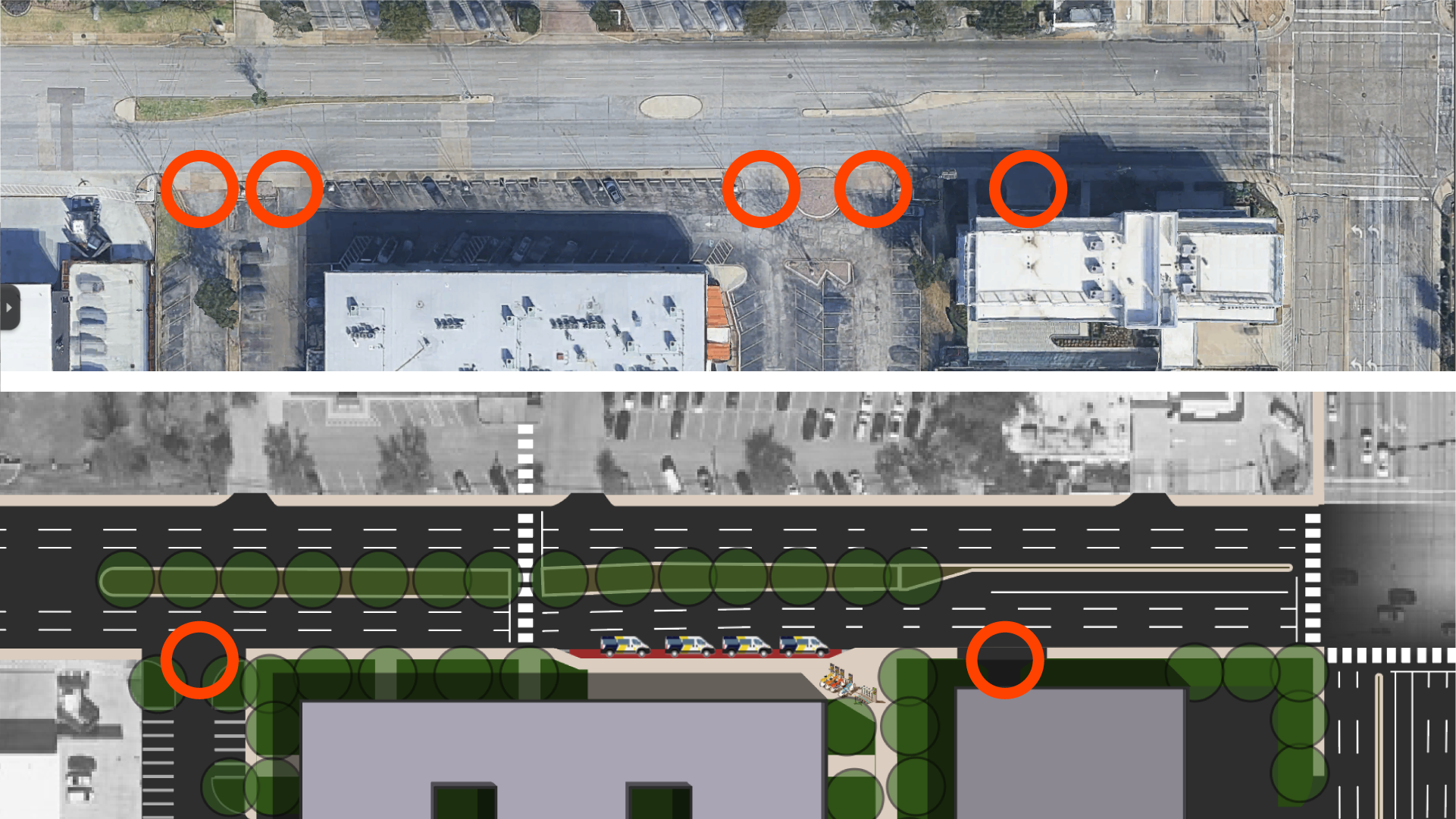
“Wait! But without left turns, how will I…”
Simple. Just turn left somewhere else where it’s safer.
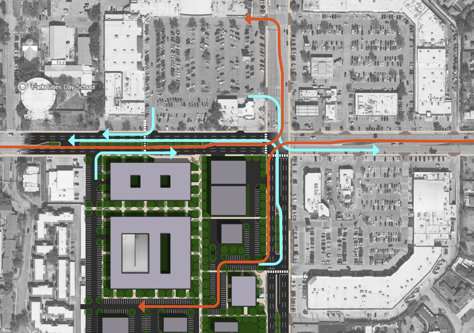
By eliminating left turns on Royal Ln, we need to keep some left turns on Preston Rd. We can enhance the safety of these remaining left turns—for both drivers and pedestrians crossing there—by giving them traffic signals. To maintain traffic flow, we can use coordinated signal timing so that all the lights on Preston Rd turn green at the same time.
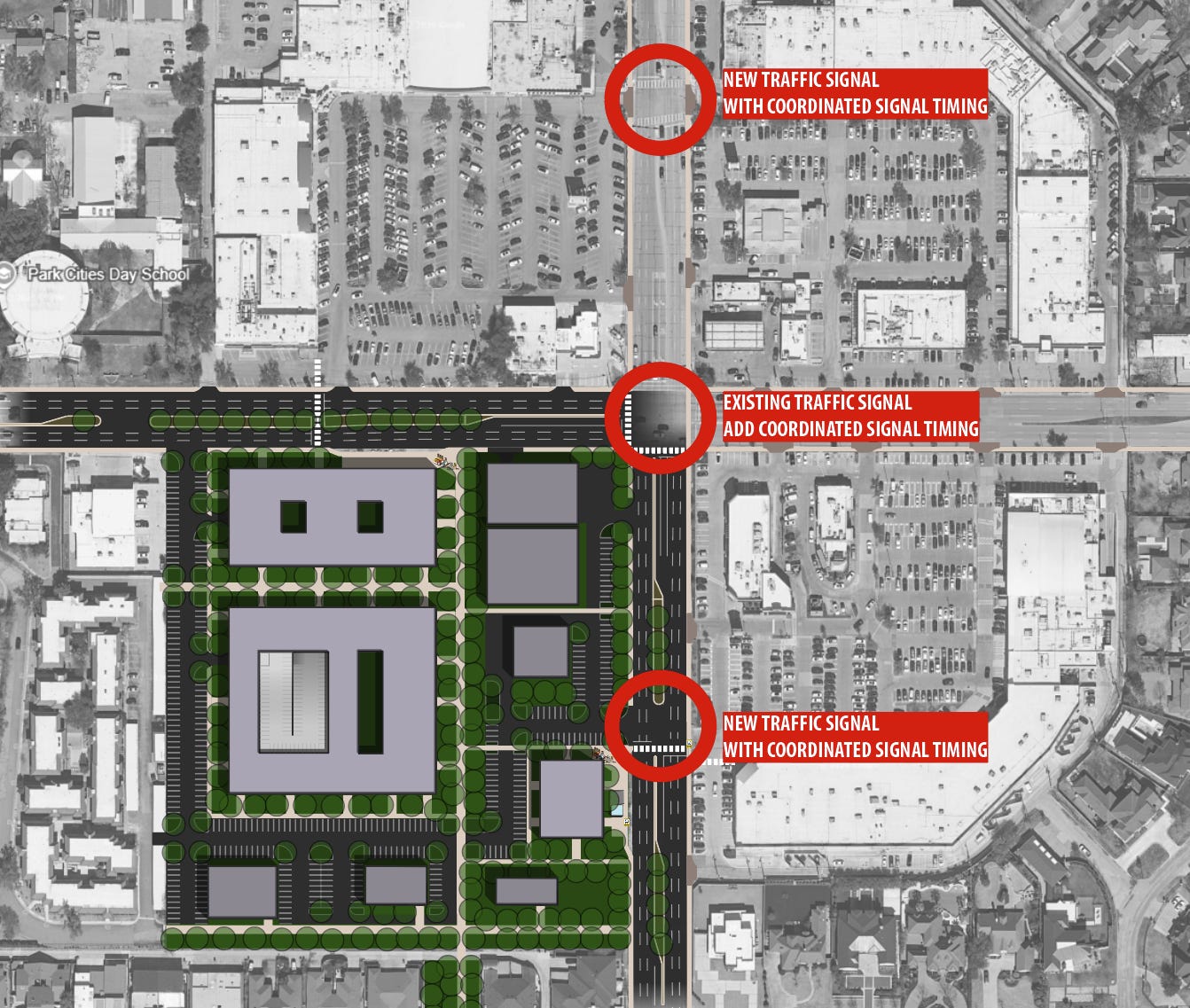
While, at first glance, removing unsignalized left turns may seem like a drastic oversimplification, anyone whose driven on these roads knows just how dangerous, scary, and inefficient these left turns really are. Over 53% of cross-traffic crashes involve left turns, and over 22% of car accidents in general involve left turns. Left turns are involved in a quarter of all accidents involving pedestrians, and nearly 90% of left turns collisions are the fault of the driver.
Consolidate driveways into streets
It goes without saying that the southwest corner is a hot mess.
I struggle to find the words. Just look at it and see for yourself.


Can you imagine how ridiculous it would be to spend $800 million and not fix this mess? And call that walkability?
Now, this would require a lot of coordination and cooperation, but here’s what I suggest at a high level:
Consolidate parallel driveways into a named street.
Remove barriers so parking can be consolidated and shared.
Orient buildings around shared-use paths.
Connect site to Orchid Ln via pocket park trail (as detailed earlier).
Connect site to Royal Ln condos (west) with a pedestrian gate.
Convert surplus land into greenways / linear parks.
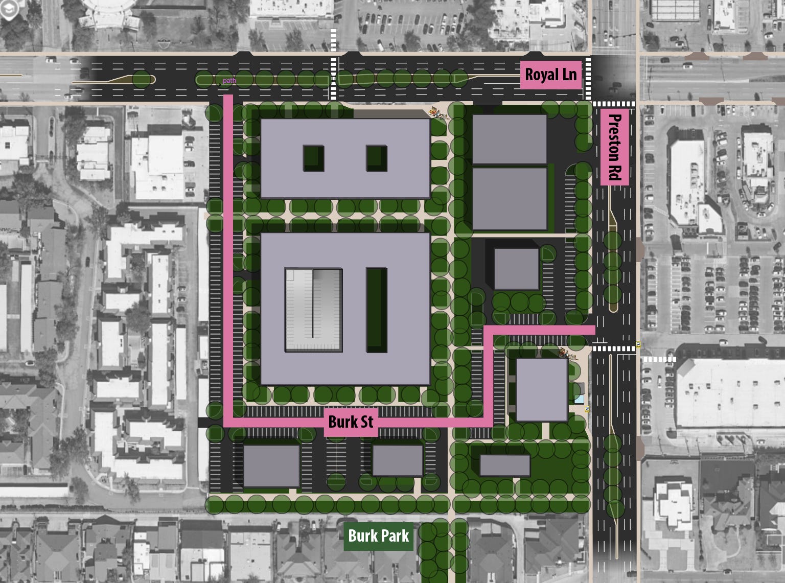
The end result is a simple, efficient, and walkable grid that not only serves Burk’s project but the entire neighborhood, including businesses outside Burk’s project. It also lays a walkable foundation for future redevelopment of adjacent properties.
Of course, as I said at the very beginning of this article, I’m not presenting an actual plan. I’m not a representative of the Preston Hollow neighborhood, nor am I claiming to speak on their behalf. An actual plan would require a lot of time and input from neighbors, businesses, and the city.
I imagine after reading this you may have already thought of several ideas better than what I’ve presented here. Good! I’m sure there are plenty of holes to poke in my drawings. I haven’t even covered all my ideas yet! (This is already my longest article yet, and I had to stop somewhere) My purpose for this article was to simply get ideas flowing so we can start a meaningful and productive conversation about how we truly make Preston Hollow more walkable.
Earn your height
Before we end, there’s one more thing we need to talk about: the height limit.
As I’ve exhaustively explained in my previous article, height itself was never the issue.
Height tracks with cost, and cost tracks with risk. My contention has always been that the projects introduces far more risk than its worth. More risk than what few housing it produced. More risk than the tax revenue it may or may not have generated.
The function of height limits, in my view, is two-fold:
Regulate the flow of capital into a neighborhood so that it’s gradual, not cataclysmic.
Give the neighborhood leverage to receive value in exchange for absorbed risk.
Up until now, the dialogue between the neighborhood and the developer has sounded something like this:
Burk: “Would you let me build tall?”
PH: “Why would we?”
Burk: “Because I want to.”
PH: “Then no.”
What needs to happen is the dialogue needs to flip so that the height is motivated not out of vain desire, but out of necessity to accomplish the goals shared between the developer and the neighborhood.
Burk: “Would you let me build tall?”
PH: “Why would we?”
Burk: “So I can cover the costs of fixing the stroads, building the pocket parks, adding upgraded transit and bicycle facilities, and planting new street trees all over. I also need additional height so can fit enough residential density to support local businesses and public transit.”
FOOTNOTES:
For simplicity, when I say Burk, I simultaneously mean the company, Burk Interests, and the person who owns the company, Leland Burk. Whenever I say Burk’s project or the project, I’m talking about his proposed mixed-use development at the southwest corner of Royal Ln and Preston Rd.
I don’t know if my article had anything to do with hearing being rescheduled. More likely it was the legal request by Preserve Preston Hollow. That said, I worked long and hard on that last article, so I like to imagine it had at least some impact.
For simplicity, any time I say Jane’s book or her book I specifically mean The Death And Life of Great American Cities.
I didn’t list these examples (bike shop, plant shop, art gallery, blackbox theater) because I know for a fact whether neighbors want any of them (I don’t know). I only listed them as examples of uses I’ve personally observed are present in other neighborhoods yet not at Preston/Royal, and their exclusion could possibly be for lack of qualified accommodations. For example, maybe Preston/Royal doesn’t have a plant shop yet not for lack of interest but for lack of retail space with ample sunlight. Or maybe it lacks a bicycle shop not for lack of potential customers but for lack of cycling infrastructure.
Technically, Highland Park Village lost its bus stop when the Town of Highland Park voted to leave DART back in May. However, there is still a bus stop a couple blocks away on the Dallas side of Preston Rd.